
Mining Drone Guide: Use Cases, Workflows, and How to Choose the Right System
Mining drones help mines work safer and more efficiently by capturing high-resolution data from the air and inside hazardous spaces. From open-pit surveys and stockpile volumes to underground inspections and tailings dam checks, drones for mining are now a core tool for planning, operations, and safety teams. → Jump to the best mining drones for mine surveys, underground inspections, and mine site monitoring. In surface and underground mines, traditional inspection and survey methods can be slow, risky, and labor-intensive. Survey crews working on unstable slopes, inspectors entering stopes or shafts, and technicians climbing conveyors, crushers, or transfer towers all face elevated exposure to falls, rockfall, vehicle traffic, and other hazards. Limited visibility and access can also make it hard to spot issues early—leading to unplanned downtime and costly failures. Mining drones (sometimes searched as “mine drones”) solve this by putting cameras and specialized sensors on an aircraft instead of a person. Teams can map large areas fast, create detailed 3D models for planning and design, and capture repeatable datasets for stockpile reconciliation, geotechnical monitoring, and safety checks—without sending people into higher-risk areas. Other common terms for a mining drone include:- Mining drone
- Mine drone
- Mine survey drone
- Underground mine inspection drone
- Open-pit survey drone
- Stockpile volume drone
Best Mining Drones: Top sUAS for Mine Surveys, Safety, and Reclamation
Want to buy or rent a mining drone—or choose a platform to launch or scale your mine’s drone program? Below are proven mining-ready options available through MFE’s sUAS team. [Related: sUAS / Drones from MFE]1. Flyability Elios 3: Underground Mine Inspection Drone
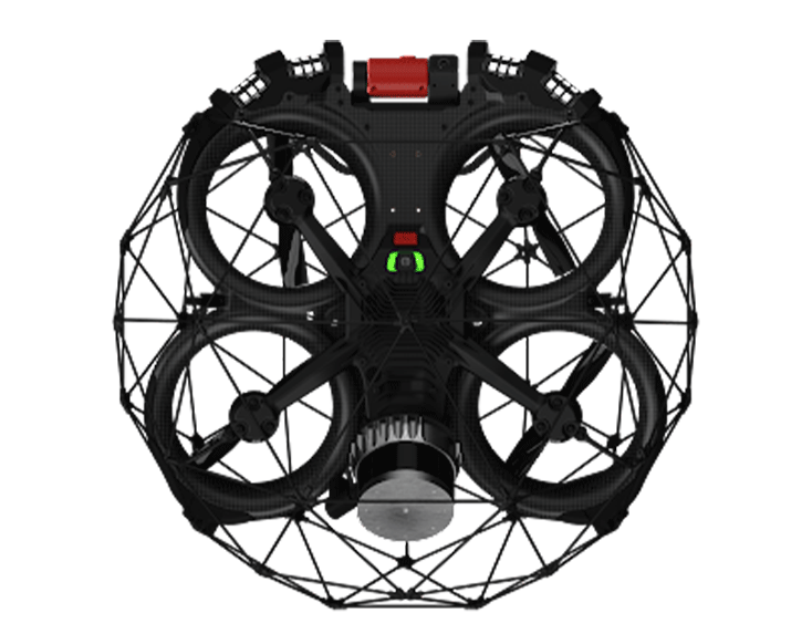 The Flyability Elios 3 is a collision-tolerant indoor drone designed for GPS-denied, confined-space inspections—making it a strong fit for underground mines.
In block caves, room-and-pillar mines, and other underground operations, the Elios 3 can fly into stopes, ore passes, drawpoints, drifts, crushers, and conveyors to collect visual and mapping data without sending personnel into hazardous areas.
The Flyability Elios 3 is a collision-tolerant indoor drone designed for GPS-denied, confined-space inspections—making it a strong fit for underground mines.
In block caves, room-and-pillar mines, and other underground operations, the Elios 3 can fly into stopes, ore passes, drawpoints, drifts, crushers, and conveyors to collect visual and mapping data without sending personnel into hazardous areas.
- Protective cage for work in tight, contact-prone environments
- LiDAR + SLAM mapping to support 3D models in GPS-denied areas
- Lighting built to capture usable visuals in low-light headings
- Supports pre-entry checks, post-blast inspections, hang-up checks, and documentation without entry
2. DJI Matrice 350 RTK: Open-Pit Mine Survey and Site Inspection Drone
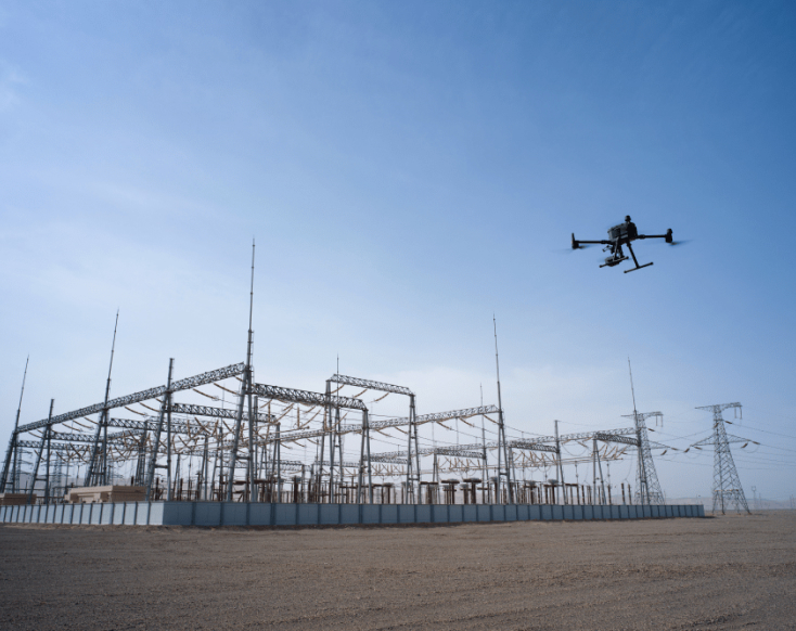 The DJI Matrice 350 RTK is a rugged, enterprise-grade platform built for large outdoor sites that need accurate mapping, inspections, and environmental monitoring.
For open-pit mines, waste dumps, and tailings facilities, the Matrice 350 RTK pairs RTK positioning with advanced payloads (photogrammetry cameras, LiDAR, thermal) to support everything from haul-road design to highwall documentation.
The DJI Matrice 350 RTK is a rugged, enterprise-grade platform built for large outdoor sites that need accurate mapping, inspections, and environmental monitoring.
For open-pit mines, waste dumps, and tailings facilities, the Matrice 350 RTK pairs RTK positioning with advanced payloads (photogrammetry cameras, LiDAR, thermal) to support everything from haul-road design to highwall documentation.
- RTK positioning for repeatable mapping missions
- Designed for demanding outdoor conditions common on mine sites
- Supports multiple payload types for mapping, inspection, and monitoring workflows
- Scales across survey, environmental, and maintenance teams
3. DJI Mavic 3 Enterprise Series: Quick-Deploy Mine Survey and Stockpile Volume Drone
 The DJI Mavic 3 Enterprise Series is a compact platform that brings professional survey and inspection capabilities to mine sites without the logistics of a larger airframe.
Quarries, small-to-medium pits, and contractors often use the Mavic 3 Enterprise Series for frequent stockpile measurements, pit surveys, and visual inspections—especially when fast deployment matters.
The DJI Mavic 3 Enterprise Series is a compact platform that brings professional survey and inspection capabilities to mine sites without the logistics of a larger airframe.
Quarries, small-to-medium pits, and contractors often use the Mavic 3 Enterprise Series for frequent stockpile measurements, pit surveys, and visual inspections—especially when fast deployment matters.
- Minimal setup time for frequent short missions
- High-resolution visual capture for site documentation
- Practical option for sites launching a drone program or supplementing contractor work
4. DJI Mavic 3 Multispectral: Reclamation and Environmental Monitoring Drone
 The DJI Mavic 3 Multispectral is built for vegetation and environmental monitoring—making it a strong fit for reclamation, land management, and compliance work around mine sites.
Environmental teams and consultants can use multispectral data to track revegetation progress, spot stressed vegetation, and create repeatable documentation for reporting and long-term monitoring.
The DJI Mavic 3 Multispectral is built for vegetation and environmental monitoring—making it a strong fit for reclamation, land management, and compliance work around mine sites.
Environmental teams and consultants can use multispectral data to track revegetation progress, spot stressed vegetation, and create repeatable documentation for reporting and long-term monitoring.
- Multispectral + RGB capture for vegetation monitoring workflows
- Repeatable datasets for reclamation and closure documentation
- Compact form factor suited to small-team field operations
5. Voliro T: NDT Drone for Mine Infrastructure
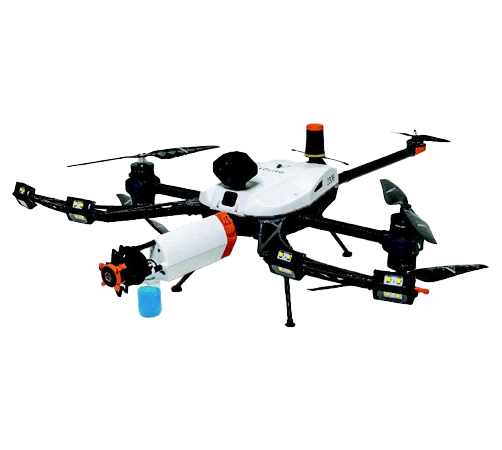 The Voliro T is an NDT drone that can perform contact-based inspections on vertical and overhead surfaces—making it a strong option for certain mine infrastructure and processing facility use cases.
In plants, load-out facilities, and other mining infrastructure, the Voliro T can carry NDT payloads to collect thickness and condition data on structures that typically require scaffolding, rope access, or lifts.
The Voliro T is an NDT drone that can perform contact-based inspections on vertical and overhead surfaces—making it a strong option for certain mine infrastructure and processing facility use cases.
In plants, load-out facilities, and other mining infrastructure, the Voliro T can carry NDT payloads to collect thickness and condition data on structures that typically require scaffolding, rope access, or lifts.
- Designed for contact-based inspection workflows where direct readings are required
- Supports access to vertical and overhead surfaces
- Can reduce reliance on scaffolding or rope access for some inspection tasks
What Is a Mining Drone?
A mining drone is a drone used to collect visual and sensor data across a mine site to support surveying, inspection, safety, and environmental work. In practice, “mining drone” is less about a special aircraft and more about a drone system that’s configured for mining workflows—meaning it can capture the right data (photos, video, thermal, LiDAR, multispectral), reliably operate in mining conditions (dust, wind, low light, tight spaces), and produce outputs teams can actually use (maps, 3D models, measurements, and repeatable documentation). A helpful way to think about drones for mining is that they do two jobs:- They reduce exposure by allowing observation and documentation without sending people into higher-risk areas.
- They compress time by collecting sitewide data quickly and turning it into maps and models that support planning and decisions.
Mining drones usually fall into two buckets
1) Mining survey and mapping drones
These are used to measure and model large areas—open pits, quarries, waste dumps, haul roads, and stockpiles. The output is typically a photogrammetry model, orthomosaic, point cloud, contours, or a volume calculation. Common mining survey drone use cases include:- Stockpile and ROM volume measurements
- Topographic surveys for mine planning and design
- Highwall and bench documentation
- Progress tracking for construction, earthworks, and reclamation
2) Mining inspection and monitoring drones
These are used to visually assess conditions, document risk, and monitor change over time—especially in places where access is difficult or exposure is high. Common mining inspection drone use cases include:- Underground stope and void observations (often with LiDAR mapping)
- Conveyor, crusher, and plant asset inspection from a safer vantage point
- Tailings dam and embankment documentation
- Post-blast checks and pre-entry visual assessments
Underground vs. surface mining: why it matters
An underground mining drone is typically built for GPS-denied environments. It may rely on onboard sensing and mapping (often LiDAR + SLAM) to navigate and create usable 3D models in darkness, dust, and confined headings. Surface mining drones (open pit and quarry) are usually optimized for mapping efficiency and repeatability across large outdoor areas, where conditions include wind, wide temperature swings, and long travel distances between targets. Both are “mining drones,” but the requirements are different—and choosing the right class of drone starts with knowing whether you’re solving a mapping problem, an inspection problem, or both.Where Mining Drones Are Used
Mining operations have a wide range of “drone environments,” and each one pushes you toward a different drone class, sensor payload, and workflow. Below are the most common places drones for mining are used—along with what teams typically collect and why.Underground hard rock mines
Underground is where drones often provide the biggest safety value because access and visibility are limited, GNSS is unavailable, and many targets are inherently higher-risk. Common underground mining drone use cases include:- Stope and void observation to assess ground conditions before personnel entry
- Ore pass, raise, and chute inspections to identify blockages, hang-ups, and buildup
- Post-blast documentation and pre-entry checks in headings with limited visibility
- 3D mapping of stopes and development areas to support measurement and planning
Open pit mines and quarries
Surface mines use drones heavily for surveying, planning, and ongoing documentation across large areas. The value is speed, repeatability, and data consistency—especially when conditions change quickly. Common open-pit mining survey drone use cases include:- Topographic mapping for mine planning and design
- Bench and highwall documentation for geotechnical review
- Haul road and dump area documentation for operational planning
- Routine site progress mapping for coordination and reporting
Stockpiles, ROM piles, and volumetrics
Stockpile measurement is one of the most common day-to-day mining drone workflows because it’s frequent, measurable, and directly tied to reconciliation and planning. Common stockpile drone use cases include:- Stockpile and ROM pile volume calculations
- Material movement tracking and change detection over time
- Inventory documentation for internal planning and external reporting
Tailings dams, embankments, and geotechnical monitoring
Drones are often used to support geotechnical and environmental teams by creating consistent visual records and models of critical structures and changes over time. Common mining inspection and monitoring drone use cases include:- Routine visual documentation of tailings dams and embankments
- Mapping for drainage, erosion, and surface condition tracking
- Supporting slope monitoring programs with repeatable datasets
Processing plants, conveyors, and industrial infrastructure
Mining sites are also industrial facilities. Drones can help teams inspect and document plant assets—especially where access normally requires lifts, scaffolding, or shutdown planning. Common processing and infrastructure drone use cases include:- Visual inspections of conveyors, transfer towers, crushers, and chutes from safer vantage points
- Documentation of hard-to-reach structures for maintenance planning
- Condition checks in areas where access is constrained or exposure is elevated
Mining Drone Workflows: Mapping vs. Inspection vs. Monitoring
A mining survey drone is not solving the same problem as an underground mining inspection drone. And a drone used for routine monitoring has different requirements than one used for one-time mapping. To choose the right system, it helps to break mining drone operations into three core workflows.1) Mapping
Mapping is about measurement and modeling at scale. The goal is to create outputs like orthomosaics, point clouds, 3D models, and volume calculations. Mapping is common in:- Open-pit surveys
- Stockpile volume calculations
- Topographic modeling for mine planning
- Underground LiDAR scans of stopes and voids
2) Inspection
Inspection is about condition assessment and documentation. The goal is not always to measure precisely, but to observe, document, and identify issues that may require follow-up. Inspection use cases include:- Checking ground conditions in a stope before entry
- Looking for buildup or damage in ore passes
- Documenting highwalls for visible cracking or instability
- Visually assessing conveyors and crushers
3) Monitoring
Monitoring is about tracking change over time using consistent, repeatable capture. This includes:- Routine tailings dam documentation
- Slope and embankment visual comparison over time
- Reclamation and vegetation tracking
- Periodic stockpile reconciliation
A simple mining drone workflow model
Many mining teams combine these into a layered workflow:| Step | Purpose | Typical output |
|---|---|---|
| Map | Create a sitewide or area model | 3D model, orthomosaic, volume |
| Inspect | Visually assess specific risks or assets | Images, video, annotated findings |
| Confirm | Validate findings with targeted methods | Engineering review or ground-based measurements |
| Monitor | Track changes over time | Repeat datasets and documented comparisons |
Types of Mining Drones
Not all mining drones are built for the same environment or workflow. Choosing the right class of drone starts with understanding what problem you’re solving—and where you’re flying.Autonomous LiDAR drones (GNSS-denied mapping)
These drones are designed to operate where GPS/GNSS signals are unavailable—most commonly underground. They typically use onboard LiDAR and SLAM to navigate and create 3D models of stopes, drifts, and voids. Best suited for: underground mapping workflows where GNSS is unavailable and 3D modeling is required.Collision-tolerant indoor drones
Collision-tolerant drones are built with protective cages that allow contact with walls, ribs, and structural elements without ending the mission. In mining, these are commonly used for underground inspections (stopes, ore passes, raises) and confined industrial spaces in processing plants. Best suited for: confined-space inspection and visual documentation.Survey and photogrammetry drones
These are the workhorses of surface mining operations. They’re used for open-pit mapping, stockpile volumes, highwall documentation, and progress mapping. Best suited for: large-area coverage where repeatable mapping and measurement are priorities.Multispectral and environmental monitoring drones
Some mining workflows focus on environmental tracking and reclamation. Multispectral drones help teams track vegetation health and change over time for documentation and reporting. Best suited for: reclamation, environmental monitoring, and repeatable documentation.NDT-enabled and contact inspection drones
Some systems can physically couple sensors to vertical or overhead surfaces to support contact-based inspection workflows in processing plants and infrastructure areas. Best suited for: infrastructure inspection programs where direct readings are required and access is difficult.Underground Mining Drone Challenges (And What to Look For)
Underground drone work isn’t just flying indoors. Underground mines add constraints that can break otherwise capable drones—especially when the goal is to return usable inspection or mapping data. A practical way to evaluate an underground mining drone is to separate:- Can it fly underground?
- Can it reliably return usable data underground?
GNSS denial and navigation
Underground environments do not provide GPS/GNSS positioning. If you need 3D mapping, prioritize platforms built for GNSS-denied mapping (often using LiDAR + SLAM). If you need inspection visuals, prioritize stable handling and strong visibility in confined areas.Low light and challenging visibility
Many underground targets are dark and visually repetitive. Lighting quality and camera performance in low light often determines whether the output is actionable or just “footage.”Dust and airborne particulates
Dust can obscure visuals and reduce mapping performance, especially after blasting or in active headings. Some conditions will limit what any drone can capture, so planning and expectations matter.Airflow and turbulence in headings
Ventilation flow and tight geometry can destabilize flight. Stable low-speed handling and conservative flight planning typically matter more than top speed.Communications limits and geometry
Radio signal attenuation (corners, turns, elevation changes) can shorten effective control and video range underground. Teams benefit from clear operating procedures that account for signal loss and recovery.Confined geometry and collision risk
Stopes, raises, ore passes, and plant internals are cluttered and irregular. Collision tolerance and usable visibility at short standoff distances are common deciding factors.A quick underground mining drone checklist
- Workflow fit: mapping (3D model) vs inspection (condition documentation) vs both
- GNSS-denied capability appropriate to the environment
- Usable visuals in low light and dust
- Stable low-speed handling in confined spaces
- Deliverables your team can act on (not just raw footage)
- Proven use in industrial underground settings similar to yours
How to Choose the Right Mining Drone System
Most wrong-fit purchases happen when a team buys a platform optimized for one workflow and expects it to solve a different one, or when the drone can capture data but the site doesn’t have a pipeline to turn that data into deliverables. Use this framework to narrow options quickly.Step 1: Start with the environment
- Underground, surface, or both?
Step 2: Define the workflow
- Mapping: measurement and modeling (orthomosaic, 3D model, volumes)
- Inspection: condition assessment and documentation (screening and targeting)
- Monitoring: repeatable documentation over time (change tracking)
Step 3: Match the payload to the deliverable
- RGB/zoom camera: visual documentation and inspections
- LiDAR (often with SLAM): 3D mapping in GNSS-denied or complex geometry
- Thermal: temperature-based screening use cases
- Multispectral: vegetation and environmental monitoring for reclamation
- Contact/NDT payloads: direct readings where physical measurement is required
Mining drone decision table
| Primary use case | Environment | Workflow | Common drone class fit | Typical outputs |
|---|---|---|---|---|
| Stope/void observation and documentation | Underground | Inspection | Collision-tolerant indoor drone | Video, images, annotated findings |
| Stope/void measurement and 3D modeling | Underground | Mapping | Autonomous LiDAR (GNSS-denied) drone | Point cloud, 3D model, measurements |
| Open-pit topographic surveys | Surface | Mapping | Survey/photogrammetry drone | Orthomosaic, surface model, contours |
| Stockpile and ROM volume tracking | Surface | Mapping/monitoring | Survey/photogrammetry drone | Volumes, change tracking, documentation |
| Tailings dam documentation and change tracking | Surface | Monitoring | Survey drone (sometimes with additional sensors) | Repeat imagery, models, reporting records |
| Reclamation and vegetation monitoring | Surface | Monitoring | Multispectral drone | Vegetation indices, repeat documentation |
| Plant infrastructure inspections (visual or measurement) | Plant/surface | Inspection | Visual inspection drone or NDT-enabled drone | Visual documentation or direct readings |
Common mistakes to avoid
- Buying for the aircraft instead of the deliverable
- Assuming underground and surface needs are interchangeable
- Ignoring the data pipeline (processing, reporting, handoff)
- Treating drone inspection outputs as final answers instead of screening inputs
Mining Drone Solutions and Support
Choosing a mining drone is only part of the equation. The real value comes from building a workflow that turns drone flights into usable data—and then into decisions. At MFE, mining drone solutions are approached as part of a broader inspection, surveying, and asset management program. The focus is on the environment, the workflow, and the deliverables first—then matching the right platform and support structure to the site.Underground mining drone solutions
Underground drone programs often focus on stope and void observation, pre-entry and post-blast checks, ore pass inspections, and GNSS-denied 3D mapping workflows. Depending on whether the site needs visual screening, measurement, or both, programs may include collision-tolerant inspection drones and LiDAR-based mapping systems.Surface mining survey and mapping solutions
Open-pit and quarry operations often center their drone programs around topographic surveys, stockpile volumes, highwall/bench documentation, and routine site progress mapping. Repeatability and structured mission planning typically matter most.Environmental and reclamation monitoring
For reclamation and compliance work, programs often focus on repeatable monitoring missions and reporting-ready datasets. Consistency over time is usually more important than one-time maximum detail.Plant and infrastructure inspection support
Drone workflows can extend into processing plants and load-out facilities to support documentation and, for some use cases, contact-based measurement. These programs are often designed to reduce access burden and support maintenance planning.How MFE supports mining drone programs
- Consultative needs assessment to define environment, workflow, and outputs
- Platform and payload selection aligned to site realities
- Training focused on both flight and usable data capture
- Implementation support to integrate drone outputs into existing processes
- Ongoing technical support as the program scales
Frequently Asked Questions About Mining Drones
Can drones fly underground in a mine?
Yes. Some drones are designed for GNSS-denied environments like underground mines and can support inspection and mapping workflows. Not every drone is suitable underground—low light, dust, geometry, and communications constraints can determine whether the output is usable.Do mining drones require GPS?
Surface mining drones commonly use GNSS/GPS for positioning and repeatable mapping missions. Underground mining drones cannot rely on satellite positioning and typically use onboard navigation and mapping methods instead.Are mining drones safe to use around people and equipment?
When used within site procedures and proper operating practices, drones can reduce exposure by allowing teams to observe and document areas without entry. Mines typically establish internal procedures and coordination practices to integrate drones safely into ongoing operations.How accurate are mining drone surveys?
Accuracy depends on the platform, payload, flight planning, ground control practices (where used), and processing workflow. Many mines use drone outputs for volumes, topographic models, and repeatable documentation, and then pair drone data with traditional survey methods when higher-consequence measurement is required.Do mining drones replace inspectors or surveyors?
In most cases, no. Drones change how professionals gather information. Drone inspection is often a screening step that helps teams identify where closer review or confirmation is needed, and drone mapping feeds into engineering review and planning decisions.What does a mining drone program typically cost?
Costs vary based on the drone class, payloads, processing tools, and training/implementation support. Many sites start with a single workflow (like stockpile volumes or underground inspection) and expand as they build internal capability and see how the data supports site decisions.Do operators need special training?
Beyond any applicable aviation regulations in your region, operators benefit from site-specific training focused on mining conditions, capture best practices, risk management, and data handoff. In most programs, workflow quality matters as much as flight skill.How long does it take to see value from a mining drone?
Sites that start with a clear use case tied to decisions—such as stockpile volumes, highwall documentation, or underground stope observation—often see value quickly. Programs tend to scale more successfully when the workflow is defined before equipment is deployed.Best Mining Drones for 2025: Top sUAS for Mine Surveys, Safety, and Reclamation
Want to buy or rent a mining drone? Or looking for a platform to launch or scale your mine’s drone program?
Keep reading for the top mining-ready sUAS in MFE’s lineup.
[Related read: Best Commercial Drones & Professional Drones of 2025]
Note: All solutions below are proven in industrial environments and can be configured for mining workflows, with options for purchase, rental, and training through MFE’s sUAS team.
1. Flyability Elios 3—Underground Mine Inspection Drone

The Flyability Elios 3 is a collision-tolerant indoor drone designed for GPS-denied, confined-space inspections—making it an ideal choice for underground mines.
In block caves, room-and-pillar mines, and other underground operations, the Elios 3 can fly into stopes, ore passes, drawpoints, drifts, crushers, and conveyors to collect visual and LiDAR data without sending personnel into hazardous areas.
- Collision-tolerant cage. Protective carbon-fiber cage lets the drone bounce off ribs, supports, and obstructions while maintaining flight stability.
- LiDAR-powered 3D mapping. SLAM-based navigation and LiDAR mapping create 3D models of stopes, voids, and underground workings.
- High-intensity lighting. Powerful, dust-optimized lighting reveals loose ground, rockfall hazards, and structural issues in low-visibility headings.
- GPS-denied operations. Purpose-built to operate underground where GNSS is unavailable, with intuitive pilot tools for line-of-sight and beyond-line-of-sight flying inside voids.
- Mine safety use cases. Ideal for pre-entry checks, post-blast inspections, hang-up checks, and documenting ground conditions without exposing crews.
Buy or rent the Flyability Elios 3.
2. DJI Matrice 350 RTK—Open-Pit Mine Survey & Inspection Drone
The DJI Matrice 350 RTK is a rugged, enterprise-grade platform built for large outdoor sites that need accurate mapping, inspections, and environmental monitoring.
For open-pit mines, waste dumps, and tailings facilities, the Matrice 350 RTK pairs high-precision RTK positioning with advanced payloads (photogrammetry cameras, LiDAR, thermal) to support everything from haul-road design to dam inspections.
- Survey-grade RTK positioning. Delivers high-accuracy topographic surveys and stockpile volumes across large pits and mine sites.
- Rugged, mining-ready design. Long flight time and IP55 ingress protection support operations in dusty, harsh mine environments.
- Flexible payload options. Supports photogrammetry, LiDAR, and thermal payloads for pit walls, dumps, tailings dams, and process facilities.
- Fleet workhorse. Ideal as the primary platform for survey teams, environmental teams, and maintenance crews across the mine.
- Dock-ready for automation. Compatible with DJI Dock solutions, enabling automated flight programs for regular site checks and monitoring.
Buy or rent the DJI Matrice 350 RTK.
3. DJI Mavic 3 Enterprise Series—Mine Survey & Stockpile Volume Drone
The DJI Mavic 3 Enterprise Series is a compact RTK-capable platform that brings professional survey and inspection capabilities to mines without the logistics of a larger airframe.
Quarries, small-to-medium pits, and contractors can use the Mavic 3 Enterprise for frequent stockpile measurements, pit surveys, and visual inspections with a fast, easy-to-deploy drone that fits in a backpack.
- Portable RTK mapping. Combines a folding airframe with RTK accuracy, ideal for quick mine surveys and stockpile volumes.
- Integrated zoom camera. 20MP camera with powerful zoom supports detailed inspections of benches, faces, and plant equipment.
- Fast deployment. Minimal setup time lets crews capture data between other tasks or during short weather windows.
- Lower barrier to entry. Great starting point for mines launching an in-house drone program or supplementing survey contractor work.
- Versatile site tool. Supports mapping, inspection, and documentation tasks across the mine site with a single, compact platform.
Buy or rent the DJI Mavic 3 Enterprise Series.
4. DJI Mavic 3 Multispectral—Mine Reclamation & Environmental Monitoring Drone
The DJI Mavic 3 Multispectral (Mavic 3M) is built for vegetation and environmental monitoring, making it a strong fit for reclamation, land management, and compliance work around mine sites.
Environmental teams and consultants can use the Mavic 3M to track revegetation, assess slope stability indicators, and monitor water-adjacent areas near tailings dams and waste facilities.
- Multispectral sensing. Captures multispectral and RGB data for NDVI and other indices, supporting reclamation and vegetation health monitoring.
- Reclamation documentation. Produces repeatable datasets to document progress toward reclamation and closure goals.
- Compact and field-ready. Portable design allows environmental teams to operate independently without a large support crew.
- Tailings and erosion monitoring. Helps identify areas with poor vegetation cover, erosion, or other environmental risks around tailings and waste rock.
- Integration with GIS workflows. Data can feed directly into GIS and environmental reporting tools used by mining and consulting teams.
Buy or rent the DJI Mavic 3 Multispectral.
5. Voliro T—NDT Drone for Mining Infrastructure
The Voliro T is an advanced NDT drone that can perform contact-based inspections on vertical and overhead surfaces, making it a powerful tool for mine infrastructure.
In processing plants, load-out facilities, and tailings-related infrastructure, the Voliro T can carry ultrasonic and other NDT payloads to measure wall thickness and assess corrosion on structures that normally require scaffolding or rope access.
- Omnidirectional flight and thrust vectoring. Allows the drone to fly, hover, and press probes against vertical, inclined, and overhead steel with precise control.
- Contact-based NDT testing. Supports ultrasonic and other NDT payloads for thickness measurements on chutes, tanks, conveyors, and structural steel.
- Reduced scaffolding and downtime. Minimizes the need for scaffolding, lifts, or rope access, helping mines reduce outage time and inspection costs.
- High-risk areas made accessible. Reaches exposed or congested areas around crushers, transfer towers, and process vessels that are difficult to access safely.
- Program-level inspection tool. Fits into broader asset integrity and reliability programs across processing plants and supporting infrastructure.