Select Page

DJI Zenmuse L2

UAV, ROV, NDT For Sale


Beyond The Surface: DJI Zenmuse L2 Unlocks New Layers of LiDAR Detail and Precision.

Introducing the DJI Zenmuse L2

The DJI Zenmuse L2 is reshaping the landscape of aerial LiDAR technology, setting a new benchmark for surveying precision and operational efficiency. Outfitted with a top-tier IMU and a sharp-resolution mapping camera, it turns DJI flight platforms into the ultimate geospatial data collection tools. At its core is the frame LiDAR system, which operates similarly to a high-speed camera, swiftly capturing a series of snapshots in detailed frames of laser data to map large areas quickly and with detailed accuracy. This integration streamlines the data-gathering process and boosts the precision of the collected geospatial information. With its capacity to document intricate details from the skies and the ease of an all-in-one solution with DJI Terra, the Zenmuse L2 is the critical connection between complex raw data and clear, actionable insights. Whether for charting terrains or examining infrastructure, the Zenmuse L2 serves as your dependable eye in the sky, transforming the way accuracy and efficiency are perceived in aerial surveying.

Zenmuse L2 Frame-Based LiDAR: A New Frontier in Aerial Mapping

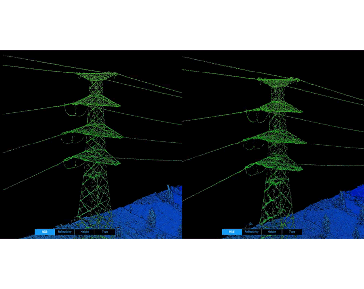
The Zenmuse L2 ushers in a new standard for aerial surveying with its frame-based LiDAR technology. Unlike traditional point-scanning methods, this system captures a wide array of data points in a single frame, vastly increasing efficiency and detail in data collection. With the ability to process up to 240,000 points per second, the L2 excels in both speed and precision, allowing surveyors to acquire more data faster without sacrificing quality. Its enhanced altitude capabilities extend its operational range, ensuring safety and expanding its utility across various surveying conditions. Whether mapping dense forests or intricate urban landscapes, the Zenmuse L2 offers professionals a powerful tool to capture the world with unparalleled clarity.

Enhanced Detection Range by 30%

The L2 can discern features from as far as 250 meters at 10% reflectivity and 100 klx lighting, extending to 450 meters at 50% reflectivity in total darkness (0 klx). The operational altitude has also been raised to 120 meters, substantially boosting operational safety and efficiency.

Point Cloud Rate: 240,000 Points per Second

The L2 can achieve a peak emission rate for point clouds of 240,000 points per second in both single and multiple return modes, enabling a more rapid collection of point cloud data within a set timeframe.

Reduced Laser Spot Size for Richer Point Cloud Detail

The L2 features a laser spot size that’s been narrowed to 4×12 cm at 100 meters, which is just one-fifth the size of its predecessor, the L1. This allows for the detection of smaller objects in greater detail and improves penetration through thick vegetation, resulting in more precise digital elevation models (DEM).

Two Scanning Modes

The L2 provides two versatile scanning modes to suit various user needs. Its repetitive scanning mode ensures consistent and precise point clouds, ideal for tasks requiring high-accuracy mapping. Alternatively, the non-repetitive scanning mode allows for deeper penetration, capturing more structural details, which is especially beneficial for applications like power line inspection, forestry surveying, and similar activities.

Supports 5 Returns

Within lush, vegetated environments, the L2 can obtain an enhanced number of ground points beneath the layers of foliage.

Enhanced Precision and Readiness

L2’s high-accuracy IMU system, self-developed for superior performance, is paired with the drone’s RTK positioning to provide highly accurate post-processing data fusion. This results in precise information regarding position, speed, and orientation. Notably, the IMU system requires no warm-up time, being instantly operational upon power-up, which, coupled with the drone’s immediate readiness once the RTK achieves FIX status, significantly streamlines field operations.

Yaw Measurement Precision

  • Real-time accuracy: 0.2°
  • Post-processing accuracy: 0.05°

Pitch and Roll Measurement Precision

  • Real-time accuracy: 0.05°
  • Post-processing accuracy: 0.025°

Advanced Imaging with the RGB Mapping Camera of Zenmuse L2

The Zenmuse L2’s RGB Mapping Camera, featuring a 4/3 CMOS sensor and a mechanical shutter, marks a significant leap in aerial imaging technology. With an expanded pixel size of 3.3 μm and an impressive 20 MP resolution, it dramatically enhances image quality and enriches true-color details in point cloud data. The camera’s rapid capture capability, at a minimum interval of just 0.7 seconds, and a shutter count of up to 200,000 times, make it both efficient and cost-effective for extensive operations. Versatile in function, this RGB camera is not limited to point cloud data collection; it can effortlessly switch to capturing high-quality photos and videos, or gather images for visible light mapping, making it an invaluable tool for a wide range of aerial surveying and mapping applications.

Enhanced Operational Software Experience

The enhanced operational software of the DJI Zenmuse L2 offers a user-friendly experience with several key features. DJI Pilot 2 provides versatile viewing options, including RGB and point cloud formats, along with real-time distance measurement for improved flight safety. After flight, operators can easily access and merge 3D point cloud models for thorough analysis. The system also supports RTK base stations to ensure data accuracy in complex environments. With the addition of auto-generated Task Quality Reports and streamlined one-click processing in DJI Terra, the software simplifies post-flight data handling, making the entire operational process more efficient and user-centric.

Diverse Flight Path Types

Accommodates Various Route Types including Waypoint, Area, and Linear Paths, adaptable for surveying tasks across diverse environments.

Real-Time Point Cloud Visualization

While in use, DJI Pilot 2 offers three viewing options: RGB, point cloud, and a combined point cloud/RGB format, allowing for clear and intuitive display of operational data. The inclusion of RNG (Laser Rangefinder) function provides vital distance measurements between the LiDAR unit and the central object in the field of view, contributing to safer flight operations. Additionally, it features four dynamic point cloud coloring settings, including Reflectivity, Height, Distance, and RGB, for enhanced real-time data visualization.

Point Cloud Model Review and Merging

Post-operation, the 3D point cloud model can be directly accessed in the album for review. Additionally, 3D point cloud models from multiple flights can be combined, facilitating immediate on-site assessments of operational quality.

Post-Processed Kinematic (PPK) System

In challenging operational settings, users can establish RTK base stations prior to the operation to proactively mitigate any loss of RTK data caused by interference, video transmission issues, or similar problems. Post-operation, the original files can be imported into DJI Terra for the PPK (post-processing kinematic) procedure to reconstruct high-precision models.

Auto-Generated Task Quality Report

Once the point cloud data is collected, the DJI Pilot 2 app automatically creates a Task Quality Report, enabling operators to instantly and conveniently review operational outcomes on-site. This feature makes field operations more efficient and stress-free.

One-Click Processing with DJI Terra

Experience streamlined and dependable post-processing with DJI Terra by easily importing point cloud data. With just one click, you can create a standard-format 3D point cloud model, following trajectory calculation and accuracy enhancement of the point cloud. Utilize the Ground Point Type feature for ground point classification to generate a Digital Elevation Model (DEM). Additionally, assess the quality of the point cloud using the Accuracy Control and Check tool for thorough analysis.

Close

Enquiry about DJI Zenmuse L2