The DJI Zenmuse L3 marks a significant leap in drone-based LiDAR technology, building on the foundation set by its predecessor, the Zenmuse L2.
Designed for professionals who require more power, range, and flexibility, the Zenmuse L3 delivers enhanced performance in almost every area, from data precision and depth penetration to mapping efficiency and imaging quality.
It integrates cutting-edge LiDAR and RGB imaging technologies into a single, streamlined payload that works seamlessly with DJI’s enterprise drone and software ecosystem.
What makes the L3 stand out is its ability to cover more ground, capture more detail, and perform in more challenging environments than previous-generation systems.
Whether you’re mapping remote terrain or inspecting complex infrastructure, the Zenmuse L3 helps teams get the job done faster and more accurately.
Equipment Type: Drone Payload
Request a Quote
When accuracy is mission-critical and time is limited, you need more than just a tool. You need a solution that elevates performance and simplifies complex operations. The DJI Zenmuse L3 is DJI’s next-generation aerial LiDAR system, built to meet the demands of professionals who require precision, reliability, and efficiency in every flight.
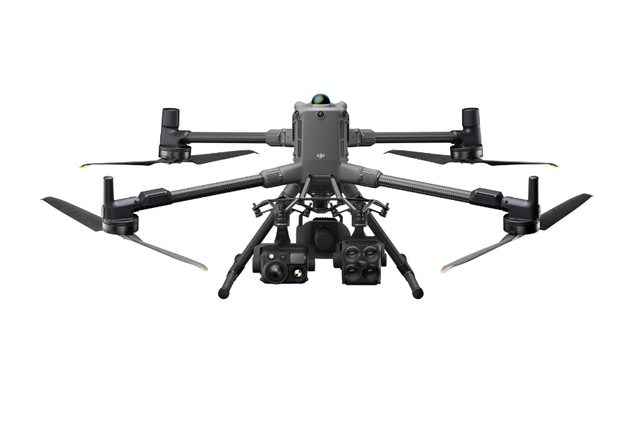
As DJI’s first long-range, high-accuracy LiDAR payload, the L3 combines advanced sensing, high-resolution imaging, and precision positioning in a compact, integrated design. Engineered for the Matrice 400 and optimized for DJI’s full ecosystem, the Zenmuse L3 delivers exceptional results in geospatial surveying, infrastructure inspection, and public safety applications—capturing more data, with greater clarity, in less time.
At the heart of the Zenmuse L3 is a powerful 1535nm laser, operating in the near-infrared spectrum. This wavelength enables longer-distance scanning, up to 950 meters, even on low-reflectivity surfaces while maintaining a Class 1 safety rating.
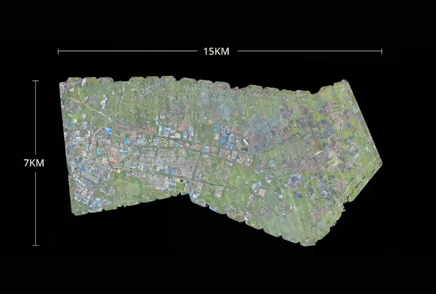
It’s the ideal balance of safety and power, allowing for high-altitude operations that boost coverage and efficiency without sacrificing precision. When mounted on the DJI Matrice 400, the L3 can cover up to 100 km² per day at a typical flight altitude of 300 meters, making it one of the most efficient payloads in its class.
The L3 also supports up to 16 returns per laser pulse, a major leap beyond conventional systems. Each return represents a surface the laser pulse hits—like treetops, branches, and the ground.
Capturing multiple returns allows the L3 to build layered point clouds that reveal both surface and sub-surface details. This is essential for mapping terrain under dense vegetation, inspecting infrastructure surrounded by foliage, or modeling complex environments with vertical depth.
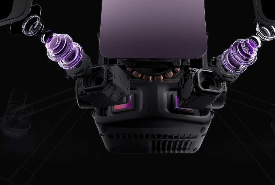
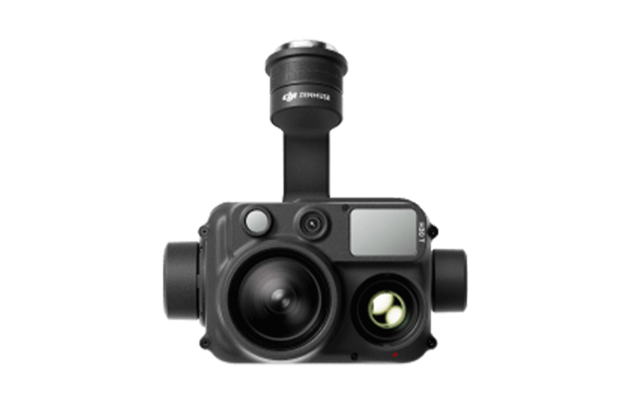
In addition to its advanced LiDAR, the Zenmuse L3 integrates a dual-camera system with two 100MP RGB sensors. These large-format M4/3 sensors deliver crisp, true-color imagery with sharp detail and enhanced fidelity, providing visual context to your LiDAR data. This is especially useful for generating high-resolution orthophotos, colorized point clouds, and accurate 3D models—all in a single flight.
The imaging system also features a mechanical shutter with a rapid 0.5-second interval, enabling clean captures even at higher flight speeds. This allows for fast, blur-free data acquisition across large areas, improving overall efficiency without sacrificing image quality.
Whether you’re mapping urban structures or monitoring construction progress, the L3 ensures both geometry and color are captured with precision.
The Zenmuse L3 is engineered for professional-grade accuracy, supporting mapping scales as fine as 1:500. At 150 meters altitude, it delivers vertical accuracy within ±3.5 cm and horizontal accuracy within ±5 cm.
This level of precision ensures reliable elevation models, tight surface reconstructions, and compliance with industry standards for surveying and engineering projects.
Beyond large-scale accuracy, the L3 excels in micro-level detection. With a laser beam divergence of just 0.25 mrad, the spot size is approximately one-fifth the size of its predecessor at the same range.
This enables the system to detect narrow features such as power lines, edges, and small branches with exceptional clarity, even when operating at high altitudes.
The Zenmuse L3 captures LiDAR and RGB data simultaneously, allowing teams to generate multiple high-value mapping outputs from just one flight. This includes point clouds for structural analysis, digital orthophoto maps (DOM) for true-color overviews, digital elevation models (DEM) for terrain insights, and textured meshes for 3D visualization.
This all-in-one data collection dramatically reduces time in the field and simplifies post-processing. Instead of flying multiple missions or switching payloads, operators can gather everything they need in one efficient pass—saving time, lowering costs, and ensuring data consistency across all outputs.
The Zenmuse L3 features an adjustable laser pulse rate, from 100 kHz to 2 MHz—giving operators full control over point density and penetration depth depending on mission needs. Whether you’re capturing dense vegetation, scanning open terrain, or extracting fine structural details, the L3 adapts to deliver the optimal balance of speed, coverage, and accuracy.
To further enhance data capture, the L3 offers three intelligent scanning modes, each designed for specific mapping objectives:
These versatile scan options give surveyors and inspectors greater control over how data is collected, ensuring consistently accurate results across varied environments.
The Zenmuse L3 is more than just a sensor, it’s a key part of DJI’s complete geospatial solution. It integrates effortlessly with the DJI ecosystem, including DJI Pilot 2 for flight operations, DJI Terra for post-processing and PPK calculations, and DJI Modify for advanced modeling and classification. It also connects with DJI FlightHub 2 for real-time mission planning and cloud-based data management.
From planning to final deliverables, the L3 streamlines every step of your workflow. With seamless hardware and software compatibility, your team can move faster, stay organized, and consistently deliver high-quality results. Get in touch today to see how the Zenmuse L3 can fit into your operations.
| Point Cloud System Accuracy | At 120m Flight Altitude:
Vertical Accuracy: 3 cm (RMSE)
Horizontal Accuracy: 4 cm (RMSE)
At 300m Flight Altitude: Vertical Accuracy 5 cm (RMSE) Horizontal Accuracy: 7.5 cm (RMSE) |
| Point Cloud Thickness | 1.2 cm@1σ (120m nadir flight altitude)
2 cm@1σ (300m nadir flight altitude) |
| Combined Horizontal FOV (Dual RGB Mapping Cameras) | 107° |
| RGB Ground Sampling Distance (GSD) | Average Value: 3 cm (300m nadir flight altitude) |
| Weight | 1.60 kg (without single gimbal connector)
The Zenmuse L3 single gimbal connector weighs 145 g. |
| Dimensions | 192×162×202 mm (L×W×H) |
| Power | 64 W (typical) 100 W (max) |
| Supported Aircraft | DJI Matrice 400 (requires the Zenmuse L3 single gimbal connector) |
| Ingress Protection Rating | IP54 |
| Operating Temperature | -20° to 50° C (-4° to 122° F) |
| Storage Temperature | -40° to 70° C (-40° to 158° F) |
| Laser Wavelength | 1535 nm |
| Laser Beam Divergence | 0.25 mrad (1/e²) |
| Laser Spot Size | Φ 41 mm@120 m (1/e²)
Φ 86 mm@300 m (1/e²) |
| Detection Range |
700 m@10% reflectivity, 350 kHz
950 m@10% reflectivity, 100 kHz 2000 m@80% reflectivity, 100 kHz |
| Wire Detection Range | 21.6mm Steel Core Aluminum Stranded Wire:
300 m@100 klx, 350 kHz
18.4mm Black PVC Insulated Wire: 100 m@100 klx, 350 kHz Range Definition: The distance at which a fully scanned section of wire in mapping achieves a point density of 4 points per meter. Test Conditions: 100 klx ambient light, 23km atmospheric visibility, LiDAR center FOV perpendicular to the wire, Non-Repetitive scanning mode, drone flying along the wire at 15 m/s, and the wire is clean and not aged. |
| Ranging Accuracy | Absolute Accuracy: ±10 mm
Repeatability: < 5 mm (1σ) |
| Minimum Effective Detection Distance | 10 m |
| Laser Pulse Emission Frequency | 100 kHz, recommended flight altitude < 500 m 350 kHz, recommended flight altitude < 300 m 1000 kHz, recommended flight altitude < 100 m 2000 kHz, recommended flight altitude < 50 m |
| Number of Returns | 4, 8, 16 returns (100 kHz, 350 kHz) 4, 8 returns (1000 kHz) 4 returns (2000 kHz) |
| Cross-Cycle Calculation | 7 times |
| Scanning Mode and FOV | Linear Scanning Mode: Horizontal 80°, vertical 3° Star-Shaped Scanning Mode: Horizontal 80°, vertical 80° Non-Repetitive Scanning Mode: Horizontal 80°, vertical 80° |
| Laser Safety Classification | Class 1 (IEC 60825-1:2014) |
| Sensor | 4/3 CMOS |
| Lens | Equivalent Focal Length: 28 mm
FOV: 73.3° (diagonal), 62° (horizontal), 41.2° (vertical) Aperture: f/2.0-f/11 |
| Shutter | Mechanical Shutter: 2-1/1500 s (f/2.0), 2-1/2000 s (f/2.8-f/11) Shutter Count: 500,000 Electronic Shutter: 2-1/16000 s |
| Photo Size | 100 MP: 12288×8192 25 MP: 6144×4096 |
| Minimum Photo Interval | JPEG: 25 MP: 0.5 s 100 MP: 1 s RAW or JPEG + RAW: 1.2 s |
| Video Specification | Video Format: MP4 (MPEG-4 HEVC/H.265) Resolution: 4K: 3840×2160@30fps FHD: 1920×1080@30fps |
| Data Collection | DJI Pilot 2 |
| Data Processing | DJI Terra |
| Data Application | DJI Modify |
| Cloud Application | DJI FlightHub 2 |
| Data Format | JI Terra supports exporting point cloud models in the following formats:
Standard Point Cloud Format: PNTS/LAS/LAZ/PLY/PCD/S3MB
DJI Modify supports importing point cloud models in the following formats: Standard Point Cloud Format: LAS |
| Raw Data Storage | Photo/IMU/Point cloud/GNSS/Calibration files |
| Standard Memory Card | CFexpress™ Type B Memory Card, sequential write speed 1500 MB/s |
| Standard Card Reader | Read/write speed > 900 MB/s |