- MFE Offshore Home
- /
- Geometrics G-882 Marine Magnetometer
Geometrics G-882 Marine Magnetometer
The Geometrics G-882 Marine Magnetometer is a high-resolution survey instrument designed to locate and map ferrous objects beneath the seafloor and underwater environments.
By passively measuring subtle disturbances in the Earth’s natural magnetic field, the system helps operators identify hidden metallic objects that may not be visible with traditional imaging methods.
The magnetometer continuously transmits magnetic field data to onboard survey software, allowing teams to visualize and map anomalies in real time during marine survey operations.
Widely used in marine archaeology, UXO detection, and geophysical surveys, the G-882 helps professionals locate shipwreck debris, pipelines, cables, anchors, and unexploded ordnance.
Its compact, towable design allows it to be deployed easily from a vessel for both shallow and deep-water surveys, making it a reliable tool for offshore inspection, seabed mapping, and underwater object detection.
Equipment Type: Geophysical Magnetometer
Benefits of the G-882 Marine Magnetometer
- Marine archaeology surveys
- Shipwreck detection
- Sous l'eau pipeline location
- Subsea cable detection
- Anchor et chain recovery operations
- Unexploded ordnance (UXO) detection
- Munitions clearance surveys
- Offshore construction site surveys
- Oil et gas exploration surveys
- Mineral exploration surveys
- Geological mapping surveys
- Seabed anomaly detection
- Sunken aircraft location
- Lost equipment recovery
- Harbor et port security scanning
- Offshore infrastructure contrôle
- Environnement site assessments
- Orphaned well detection
- Pre-lay route surveys for subsea infrastructure
- Salvage et recovery operations
- Subsea pipelines
- Subsea communication cables
- Subsea power cables
- Shipwrecks
- Sunken vessels
- Ship anchors
- Marine anchor chains
- Sunken engines
- Sunken vehicles
- Sunken aircraft
- Offshore wellheads
- Orphaned wells
- Subsea infrastructure foundations
- Steel pilings
- Mooring blocks
- Subsea drilling equipment
- Buried metallic debris
- Lost industrial tools
- Steel casings
- Metallic subsea structures
- Oil et gas
- Offshore energy
- Offshore wind
- Exploitation minière
- Marine engineering
- Offshore construction
- Subsea infrastructure
- Defense
- Maritime security
- Naval operations
- Environnement services
- Environnement remediation
- Marine archaeology
- Maritime salvage
- Sous l'eau surveying
- Hydrographic surveying
- Geophysical surveying
- Geological research
- Academic research
- Government et regulatory agencies
Acheter ou louer
Talk to Sales
Geometrics G-882 Marine Magnetometer for Detecting and Mapping Hidden Ferrous Objects Beneath the Seafloor
Finding metal objects underwater isn’t easy. Pipelines get buried, anchors are lost, shipwreck debris scatters across the seabed, and dangerous items like unexploded ordnance can remain hidden for decades. Traditional visual inspections often can’t see through sediment, murky water, or deep seabeds—leaving critical infrastructure and hazards undetected.
The Geometrics G-882 Marine Magnetometer solves this problem by detecting subtle changes in the Earth’s magnetic field caused by metal objects below the surface.
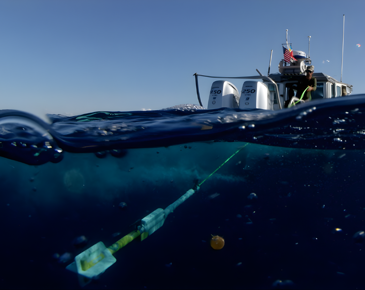
As it’s towed behind a vessel, the G-882 Marine Magnetometer continuously scans the seafloor and reveals hidden ferrous targets that would otherwise be impossible to locate. The result is a faster, safer, and more reliable way to find underwater infrastructure, hazards, and lost assets during marine survey operations.
High-Sensitivity Cesium Sensor and High-Speed Data Collection for Reliable Marine Magnetic Surveys
The Geometrics G-882 Marine Magnetometer combines a high-sensitivity cesium vapor sensor with a high sample rate of up to 20 Hz to deliver extremely detailed magnetic survey data without slowing down operations.
The cesium sensor provides industry-leading sensitivity of less than 0.004 nT/Hz rms, allowing operators to detect ferrous objects of nearly any size—from large vessels hundreds of feet away to small metallic debris that might otherwise go unnoticed.
This level of sensitivity greatly reduces the risk of missing critical targets such as buried pipelines or unexploded ordnance.
At the same time, the high-speed sampling capability allows survey vessels to collect dense magnetic data while maintaining efficient survey speeds.
Instead of forcing operators to choose between slow, detailed surveys or fast but lower-resolution data, the G-882 captures precise measurements continuously as the vessel moves.
This enables teams to cover larger areas in less time while maintaining high-quality data, helping reduce vessel time, crew costs, and overall survey duration.
Lightweight Portable Design with Flexible Tow Configurations for Efficient Marine Surveys
The Geometrics G-882 Marine Magnetometer is designed for easy deployment in demanding marine survey environments thanks to its ultra-lightweight portable design and flexible tow configurations.
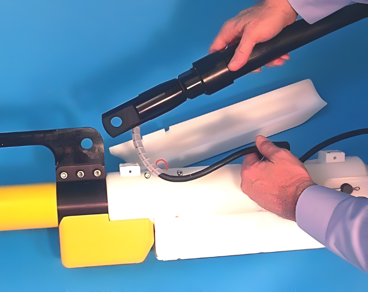
Weighing only 44 lbs with a 200-foot cable, the system includes a built-in carry handle that allows a single operator to deploy and retrieve the unit without heavy winches or large deck equipment.
This significantly reduces logistical complexity and operational costs, especially during shallow-water surveys where smaller vessels and minimal crew are preferred.
The system also supports quick conversion between nose tow and center-of-gravity (CG) tow configurations using a simple aluminum locking pin.
Nose tow allows for faster, high-speed surveys of up to 20 knots, making it ideal for shallow water operations, while CG tow enables the addition of collar weights for deeper survey applications.
This quick adjustment eliminates downtime and mechanical frustration in the field, allowing crews to adapt quickly to changing survey depths without complex reconfiguration.
Geometrics G-882 Marine Magnetometer with Deepwater Durability and Rotatable Sensor for Global Magnetic Surveys
The Geometrics G-882 Marine Magnetometer is built for demanding offshore environments with a rugged design capable of operating at depths up to 9,000 feet (approximately 2,750 meters).
Its durable, O-ring sealed fiber-wound fiberglass housing protects the internal components from extreme underwater pressure and harsh marine conditions, allowing operators to conduct both shallow and deep-water surveys with the same system.
This eliminates the need to purchase separate equipment for deep-sea operations, giving survey teams greater flexibility when working across varying water depths.
To maintain consistent performance around the world, the G-882 also features a rotatable sensor with automatic hemisphere switching.
The sensor can be adjusted to 0°, 45°, or 90° orientations to account for changes in the Earth’s magnetic field at different global latitudes.
This capability prevents signal loss or “dead zones” that can occur when crossing magnetic boundaries, ensuring reliable, continuous magnetic data collection whether the survey is conducted near the equator or in higher latitudes.
Multi-Capteur Synchronization et Side-Scan Sonar Intégration for Efficient Marine Surveys
The Geometrics G-882 Marine Magnetometer supports advanced survey workflows through its internal CM-221 mini-counter with multi-sensor synchronization and direct integration with major side-scan sonar systems.
The built-in CM-221 mini-counter allows operators to synchronize multiple magnetometers, enabling systems to be chained together for wider transverse coverage or extended longitudinal survey paths.
This capability allows teams to collect magnetic data across larger areas in fewer passes, improving efficiency while reducing noise and survey time.
The system also includes flash memory to store default settings, eliminating the need to manually reconfigure parameters each time the system is powered on.
In addition, the G-882 can interface directly with leading side-scan sonar platforms, allowing crews to perform magnetic detection and seafloor imaging in a single tow.
Instead of running separate survey passes for sonar imaging and magnetic anomaly detection, operators can gather both datasets simultaneously.
This streamlined workflow significantly reduces vessel time, lowers operational costs, and accelerates marine survey projects while still delivering comprehensive subsurface and seabed insights.
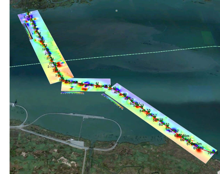
Magnetic Detection Range for Common Ferrous Objects
The table below illustrates typical magnetic detection ranges for a variety of ferrous objects of different sizes and masses. Detection distances are expressed as magnetic field anomalies measured in nanoteslas (nT) at specified distances.
Actual detection performance can vary depending on environmental conditions, sensor sensitivity, background magnetic noise, and object orientation.
Typical Detection Range for Common Objects
| Object | Plage de détection |
|---|---|
| Ship: 1000 tons | 0.5 to 1 nT at 800 ft (244 m) |
| Anchor: 20 tons | 0.8 to 1.25 nT at 400 ft (120 m) |
| Automobile | 1 to 2 nT at 100 ft (30 m) |
| Light Aircraft | 0.5 to 2 nT at 40 ft (12 m) |
| Pipeline (12 inch) | 1 to 2 nT at 200 ft (60 m) |
| Pipeline (6 inch) | 1 to 2 nT at 100 ft (30 m) |
| Iron: 100 kg | 1 to 2 nT at 50 ft (15 m) |
| Iron: 100 lb | 0.5 to 1 nT at 30 ft (9 m) |
| Iron: 10 lb | 0.5 to 1 nT at 20 ft (6 m) |
| Iron: 1 lb | 0.5 to 1 nT at 10 ft (3 m) |
| Screwdriver: 5 inch | 0.5 to 2 nT at 12 ft (4 m) |
| Bomb: 1000 lb | 1 to 5 nT at 100 ft (30 m) |
| Bomb: 500 lb | 0.5 to 5 nT at 50 ft (16 m) |
| Grenade | 0.5 to 2 nT at 10 ft (3 m) |
| Shell: 20 mm | 0.5 to 2 nT at 5 ft (1.8 m) |
Rugged Marine Housing, Real-Time Survey Software, and Global Deployment Availability
Built for demanding marine environments, the Geometrics G-882 Marine Magnetometer features a streamlined fiber-wound fiberglass housing that reduces the risk of fouling while protecting the instrument in harsh offshore conditions.
The included MagLogLite™ software allows operators to log and map magnetic data in real time while calculating the precise layback position of the sensor behind the vessel, helping crews quickly return to detected targets without extensive post-processing.
With an export-ready configuration available for international deployment, the system can be easily shipped and used across global survey operations.
Contact MFE Offshore to learn how the G-882 can support your next marine detection or geophysical survey project.
Geometrics G-882 Marine Magnetometer Technical Specifications
| Principe de fonctionnement | Self-oscillating split-beam Cesium vapor (non-radioactive) |
| Operating Range | 20,000 to 100,000 nT |
| Operating Zones | The earth’s eld vector should be at an angle greater than 10° from the sensor’s equator and greater than 6° away from the sensor’s long axis. Automatic hemisphere switching. |
| Noise | <0.004 nT/ Hzrms. (SX (export) version: <0.02 nT/ Hzrms) |
| Gradient Tolerance | 10,000 nT/m |
| Max Sample Rate | 20 Hz |
| Heading Error | < 1 nT (over entire 360° spin) |
| Output | RS-232 at 1,200 to 19,200 Baud |
| Puissance | 24 to 32 VDC, 0.75 A at power-on and 0.5 A thereafter |
| Sensor Fish | DIA: 7 cm; L: 137 cm (2.75x54 in) (with n assembly).
Weight: 18 kg (40 lb) Includes sensor and electronics and 1 main weight. Additional collar weights are 6.4 kg (14 lb) each; total of 5 capable |
| Tow Cable | DIA: 12 mm; L: 800 m (0.47 in x 2,625 ft)
Weight: 7.7 kg (17 lb) with terminations Break strength: 1,630 kg (3,600 lb) B end diameter: 30 cm (12 in) |
| Température de fonctionnement | -35°C to +50°C (-30°F to +122°F) |
| Température de stockage | -45°C to +70°C (-48°F to +158°F) |
| Altitude | 9,000 m (30,000 ft) |
| Depth | 4,000 psi (2,730 m; 8956 ft) |
| Water Tight | O-Ring sealed for up to 4,000 psi depth operation |
| Standard | Operation manual, shipping/storage container, ship kit with
tools and hardware, power supply, MagLogLiteTM, MagMapTM and MagPickTM processing software, depth transducer, altimeter. |
| En option | Steel tow cable to 6,000 m (19,600 ft) with telemetry,
longitudinal or transverse gradiometer, plastic Pelican® case, MagLogProTM, collar weights. |