- MFE Offshore Home
- /
- Ping DSP 3DSS-DX-450
Ping DSP 3DSS-DX-450
Its ability to generate simultaneous 3D imaging, side-scan views, and depth data makes it a powerful tool for professionals who need accurate, efficient, and reliable underwater insights.
Equipment Type: Side Scan Sonar
Benefits of the Ping DSP 3DSS-DX-450
- Subsea structure inspection
- Pipeline inspection
- Cable route mapping
- Offshore asset inspection
- Dredging monitoring
- Pre-dredge surveys
- Post-dredge verification
- Tailings pond mapping
- Sediment accumulation analysis
- Shallow water hydrographic surveying
- Bathymetric mapping
- Seafloor characterization
- Port security scanning
- Harbor surveillance
- Mine countermeasure operations
- Marine debris detection
- Object localization and recovery
- Underwater search operations
- Benthic habitat mapping
- Fisheries research surveys
- Environmental impact assessments
- Underwater archaeology surveys
- Shipwreck documentation
- Coastal infrastructure inspection
- Bridge and pier inspection
- Inland waterway mapping
- Flooded area assessment
- Autonomous marine vehicle missions
- Pipelines
- Power cables
- Communication cables
- Subsea umbilicals
- Structural pilings
- Bridge foundations
- Dock structures
- Pier structures
- Quay walls
- Breakwaters
- Jetties
- Offshore platforms
- Subsea manifolds
- Wellheads
- Risers
- Anchors
- Mooring lines
- Ship hulls
- Sunken vessels
- Barges
- Dredging equipment
- Tailings ponds
- Settling basins
- Reservoir floors
- Dam structures
- Spillways
- Intake structures
- Outfall structures
- Seafloor terrain
- Riverbeds
- Lakebeds
- Harbor floors
- Channel beds
- Marine debris
- Submerged vehicles
- Containers
- Ordnance
- Mines
- Archaeological artifacts
- Hydrographic surveying
- Defense
- Maritime security
- Marine construction
- Dredging
- Offshore oil and gas
- Renewable energy
- Offshore wind
- Subsea engineering
- Environmental monitoring
- Marine research
- Fisheries management
- Oceanography
- Industrial processing
- Water utilities
- Infrastructure inspection
- Civil engineering
- Transportation
- Ports and shipping
- Inland waterways
- Disaster response
- Search and recovery
- Marine archaeology
- Cultural heritage
Buy or Rent
Talk to Sales
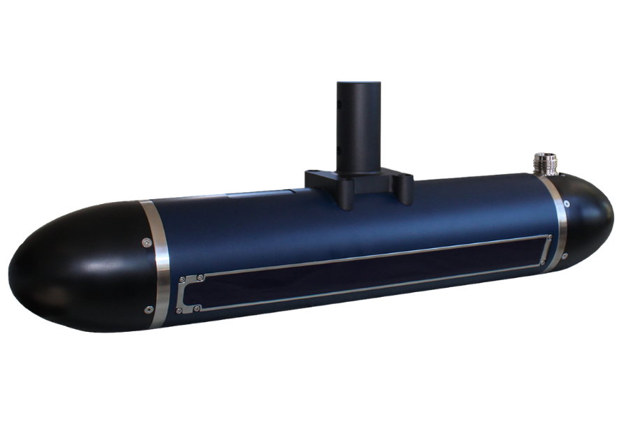
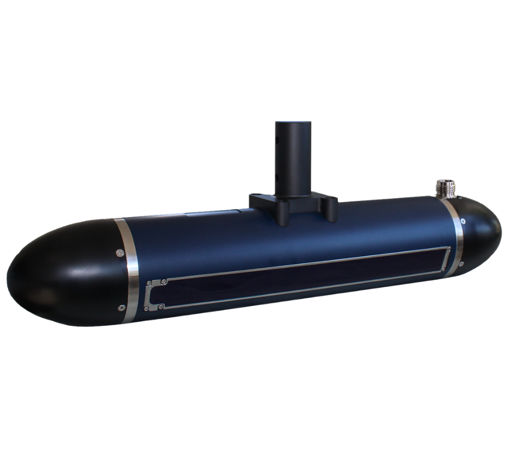
Ping DSP 3DSS-DX-450 for Real-Time 3D Underwater Imaging of Seafloor and Water Column
Seeing what’s actually happening underwater isn’t easy. Traditional sonar can leave you guessing—missing objects in the water column, distorting shapes, or forcing you to piece together multiple datasets just to understand one area. Whether you’re surveying, inspecting infrastructure, or searching for something critical, those gaps can slow you down and increase risk.
The Ping DSP 3DSS-DX-450 changes that by giving you a clear, real-time view of everything at once, from the seafloor all the way up to the surface. Instead of switching between different tools or interpretations, you get a complete, accurate picture in a single pass. That means faster decisions, fewer unknowns, and more confidence in what you’re seeing below the surface.
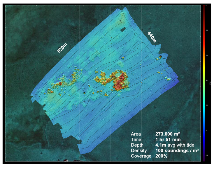
Capture 3D Sonar Imaging and Bathymetry Data in a Single Pass
The Ping DSP 3DSS-DX-450 combines simultaneous multi-mode output with wide-swath bathymetry to streamline underwater surveying like never before.
By capturing 3D side-scan imagery, 2D imagery, and precise depth data all at the same time, operators can complete fully co-registered surveys in a single pass—eliminating the need for multiple runs and significantly reducing time on the water.
At the same time, its ability to achieve bathymetric coverage up to 14 times the water depth allows teams to scan larger areas with fewer survey lines, especially in shallow environments where efficiency is typically limited.
The result is faster project completion, lower operational costs, and consistently reliable data that meets high accuracy standards without the need for costly rework.
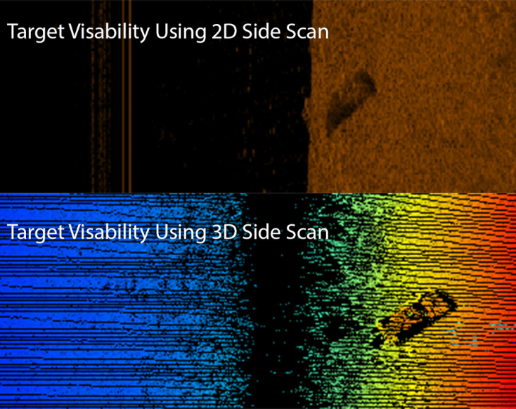
Eliminate Sonar Noise with CAATI Processing and Real-Time 3D Water Column Imaging
The Ping DSP 3DSS-DX-450 leverages patented CAATI signal processing alongside real-time 3D water-column imaging to deliver exceptionally clear and reliable underwater data.
Unlike traditional sonar systems that struggle with multipath interference and surface reflections, CAATI technology isolates true acoustic returns from the seabed, surface, and water column—eliminating noise and dramatically improving data quality.
At the same time, the system generates high-resolution 3D imagery across the entire water column, extending standard 2D resolution into fully interpretable 3D views.
This allows operators to clearly identify suspended objects, complex structures, and potential hazards in real time, reducing misinterpretation and enabling faster, more confident decision-making during critical survey and inspection operations.
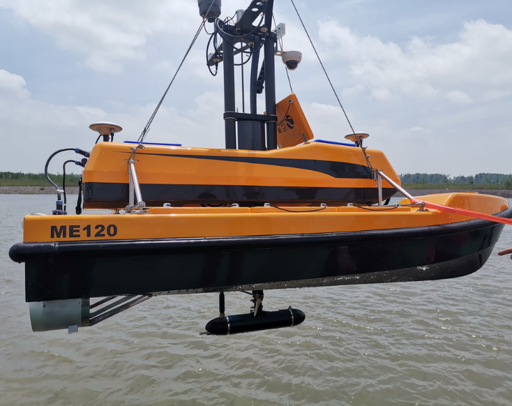
Ping DSP 3DSS-DX-450 with Compact Low-Power Design and Seamless Survey Software Integration
The Ping DSP 3DSS-DX-450 features a compact, low-power design paired with seamless third-party software integration, making it easy to deploy without disrupting existing workflows.
Weighing just 8 kg and measuring 56.8 cm x 9.8 cm, with power consumption as low as 17 W idle and 22 W typical, the system is ideal for small vessels, pole-mounted setups, and battery-powered ASVs or AUVs where size and power constraints are critical.
At the same time, its compatibility with industry-standard platforms like Hypack, SonarWiz, CARIS, QINSy, and PDS2000 ensures operators can plug the system directly into their current software environment.
This eliminates the need for retraining or costly workflow changes, allowing teams to get up and running quickly while maximizing efficiency and return on investment.
Capture, Visualize, and Report Faster with Integrated 3D Sonar Software—Optimize Your Offshore Survey Workflow
The Ping DSP 3DSS-DX-450 includes integrated Sidescan3D™ software and a built-in 3D Target Logger, enabling real-time visualization, data capture, and analysis without relying on additional platforms.
Operators can generate 3D point clouds, record raw data, and log targets with precise positioning—all within a single, streamlined workflow. This reduces post-processing time, improves data accuracy, and accelerates reporting deliverables.
For offshore teams focused on efficiency and data confidence, this system provides a more direct path from acquisition to actionable insight.
Ping DSP 3DSS-DX-450 Technical Specifications
| Operating Frequency | 450 kHz |
| Horizontal Beamwidth (2 way) | 0.4° |
| Vertical Beamwidth (selectable) | 15° - 125° |
| Mech. Transducer Tilt (fixed) | 20° |
| Electronic Transmit Tilt | -45° to 45° |
| Max. Ping Rep. Rate | ~30 Hz |
| Data Output | 2D: Range and Amplitude
3D: Range, Angle, and Amplitude |
| Max Range | 2D: 200 m per side
3D: 100 m per side |
| Max Resolution | 2D & 3D: 1.67 cm |
| Typical 2D Imaging Swath Width | 10 to 20 times sonar altitude depending on sound profile and bottom type |
| Typical 3D Bathymetry Swath Width | 6 to 14 times sonar altitude, varies with sound velocity profile and bottom type |
| Typical Bathymetry Swath Width | 6 to 14 times sonar altitude, varies with sound velocity profile and bottom type |
| Max Bathymetry Range per Side | 100 m per side |
| MRU Roll & Pitch | 0,5° |
| External Input | 1 PPS, RS-232 interface, NMEA and TSS protocols |
| Computer Requirements | PC (Quad Core, 8GB, Discrete GPU (e.g. Nvidia), MS Windows 7 or 8 (64 bit) |
| 3rd Party Software Support | QINSy, PDS2000, Hypack, SonarWiz |
| Voltage Requirements | 24 VDC +/- 10% |
| Power Consumption | 17 W idle, 22W typical (current: 0.7A idle 0.9A typical average, 3A max for 2sec., 7A peak) |
| Dimensions | 56,8 cm (length), 9,8 cm (diameter) |
| Weight | 8 kg (in air) |
| Depth Rating | 10 m |